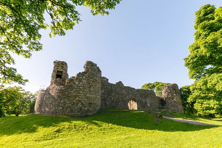
Old Inverlochy Castle stands beside the River Lochy two kilometres north of Fort William, a quadrangle of thirteenth-century curtain wall with a round tower at each corner, the railway on one side and Ben Nevis on the other. It is one of the earliest stone castles in Scotland, and it is almost unaltered, which is the historical point. It is also fenced off, which is the practical point.
Historic Environment Scotland looks after it. The grounds are open. The interior is not. What you get is a walk around the outside, a look at the towers, and the setting. That is a good twenty minutes if you are in Fort William anyway. It is not a day, and it is not the hotel.
Two mix-ups, both common.
Inverlochy Castle Hotel is a Victorian mansion of 1863 a little further north, a luxury hotel in its own grounds. Brown signs, satnav and the word “castle” send first-time visitors to the wrong gate. The medieval ruin is the one by the river, reached off the A82 just before the Mallaig turning if you are coming from town. If you have arrived at a gravel drive and a doorman, you have gone to dinner, not to a HES ruin.
It is also not Glenfinnan. The monument at the head of Loch Shiel, the viaduct, the Trust car park — that is twenty-one kilometres west, a different century and a different day. Old Inverlochy is the local castle, the one the town replaced when the fort was built on the loch. Do not put both in the same hour.
What stands is a quadrangular courtyard, about 31 by 27 metres, enclosed by a heavy curtain wall with a round tower at each corner. The largest of the four, the Comyn Tower, served as the keep — a self-contained donjon inside the circuit, named for the Comyns, who were among the most powerful families in Scotland before Robert the Bruce destroyed them.
Three sides had a water-filled ditch. The fourth faced the river, which did the same job and also fed the place: there was a water gate, so the castle could be supplied by boat from Loch Linnhe. Both landward entrances had portcullises.
Most Scottish castles were rebuilt as fashion and artillery changed. Inverlochy was abandoned early enough to escape that. The plan you walk around is essentially a 1270s plan. That is why HES bothers with it, and why a fenced ruin is still worth the stop. You can read the building from the grass: four towers, a courtyard, a river, a ditch.
It is a scheduled monument and a Category A listed building. It looks like a castle in a school book, which is rarer than it sounds.
The castle gave its name to two fights in the fields beside it.
1431: a royal army under the Earls of Mar and Caithness was beaten here by Donald Balloch, fighting for the Lord of the Isles. It is the less famous of the two, and it still matters for anyone trying to understand how much of the west was not, in practice, the king’s.
2 February 1645: James Graham, Marquis of Montrose, campaigning for Charles I, brought an army over the winter mountains from the Great Glen in a move his opponents thought impossible, and fell on a Campbell force at dawn. It was one of the most complete victories of the civil wars in Scotland, and one of the more audacious marches in British military history. The Campbells were caught between the castle, the river and the mountain. The numbers and the weather are the story; the ruin is the marker.
You will not see a battlefield trail. You will see grass, a fence, and a railway. The battles are why the name is on the map.
The ruins are unstable and the castle is closed to visitors. Historic Environment Scotland has had access restrictions in place as a precaution while it inspects and repairs high-level masonry. Some of the grounds are accessible. There is no visitor access to the castle itself. You look through protective fencing.
This has been the position for several years, not a temporary afternoon. In 2026 the site was still closed inside the fence; vandals had also breached the fencing, which does not change the rule. Do not step around it. Do not treat a gap as an invitation. Police Scotland’s line, when the fence was damaged, was that gaining entry poses a risk and should be avoided.
HES’s own getting-here page is the live notice. Check it before you make a special trip. Older websites, including some that still say “open at all times”, are describing a previous state.
What you actually get, then: the exterior, the towers from the grass, the river, the railway bridge, the mountain behind. For many people that is the photograph they wanted. For anyone who came to climb a stair and stand in a courtyard, it is a disappointment you can avoid by reading this paragraph first.
The setting is the reason to come even when the gate is locked.
The River Lochy curves around the north side on its way to Loch Linnhe. Immediately west, the West Highland Line crosses on a bridge. Trains into Fort William run past the towers. On a summer morning that can include the Jacobite leaving town — a coincidence of Victorian engineering and a thirteenth-century wall, not a scheduled show.
South and east, Ben Nevis and the Aonachs fill the skyline when the cloud lifts. The castle sits on the flat at the foot of all that, which is why it was built here: control of the river mouth and the glen, not a romantic view. The view is the by-product.
The ground is grass and can be wet. There are no facilities. No café, no toilets, no shop. The aluminium works and the modern roads are part of the same flat. It is not a manicured ruin in a park. It is a working edge of town that happens to have a 1270s castle on it.
Two kilometres north of the town centre, signposted off the A82, grid reference NN 121 755. From Fort William, if you reach the roundabout for the Mallaig road you have gone a fraction too far; the turning is before it. You cross toward the river and a small parking area. HES says parking is available. It is a handful of spaces, not a visitor-centre car park. Do not block the access.
It is walkable from town in about half an hour, and the Great Glen Way passes nearby. That is the better approach if you have already parked in town for the day — see parking in Fort William. Driving out for a twenty-minute look is how people spend longer in the car than at the castle.
Free. Unstaffed. No ticket. Exterior only, as above. Daylight is the limit that matters; there is nothing to light the place, and the grass is uneven.
The attraction page is the short version of the same facts.
Old Inverlochy and the Commando Memorial sit on the same road north. The castle is the first stop; Spean Bridge is another ten minutes up the A82. Do the ruin on the way out, the bronzes and the Nevis view on the way, and you have the two free historic stops north of town without doubling back through the High Street.
Do not confuse the two. One is a fenced medieval courtyard by a river. The other is three 1952 figures on a hillside. Both are free. Both take less time than people allow. The memorial piece is the other half of that hour.
A town day that wants history without a mountain can run: museum on Cameron Square, walk or short drive to Inverlochy, back along the canal if you have the legs. The West Highland Museum tells the Jacobite and garrison story the ruin only implies.
Allow twenty to thirty minutes at the fence. Longer only if you are walking in from town or waiting for a train to cross the bridge.
Go for the towers against the mountain, and for a castle that has not been rebuilt into something else. Do not go expecting rooms, a stair, a guidebook on a stick, or a café. Do not go in the last hour of daylight without a torch for the grass. Do not climb the fence.
Queen Victoria, shown the place in 1873 after cosmetic repairs, is supposed to have said there was little left of it to see. She was looking for a palace. What is left is the plan, the river, and the fact that it is still here. That is enough for the stop. It is not enough for a detour from Oban. If the cloud is down on Nevis, this is a better use of half an hour than sitting in the car. The castle will still be fenced when you come back.